
The established players like Garmin, Navico (B&G/Simrad/Lowrance) & Raymarine better watch out. Tiny company Orca is storming ahead with new major features on a regular basis. Now Orca have introduced Sailboat weather-based routing.
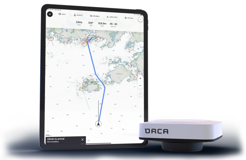
The tiny company Orca is forging ahead at speeds the established players could only wish for. Not long ago they introduced the “Orca Core”, which we installed on our centre console test boat last year.
The Orca core is a tiny “device” that is “kind of” equal to the “insides” of a normal chart plotter – but without a display. Orca Core then adds NMEA 2000 interface, GPS receiver, 9 axis inertial motion unit and an electronic compass. All in a small unit consuming less than 200 mAh. (A Garmin 19x GPS ONLY receiver consumes roughly the same)
Then you connect your phone or tablet to the “Core” unit, and you have a chart-plotter. Orca currently can deliver their own “Marine” tablet based on Android – but we did not quite think it would be good enough for the sun and temperatures in the Med. So, we have kept the Orca Core as our “Backup” chart-plotter + GPS/inertial motion unit replacing the Simrad Precision 9 heading sensor. But it might change with Orca’s upcoming launch of a new “marine tablet” computer.
Orca Core’s benefit is, in our opinion, that it is much easier for inexperienced guests on board to use – and for them to set a safe route to our home harbour if something happened. Orca Core can control the Simrad autopilot.
Teaching someone to do the same on Simard/B&G would require ½ day of training and repeated “re-trainings” as it is not intuitive at all. Even I need a bit “re-training” after 6 months of not sailing with Simrad or B&G. On Orca it is easy-peasy. Garmin is the only other contender in the “Easy to route” part but G2/G3 vision maps plus Garmin Autorouting could be a bit of a gamble from time to time.
Follow Marine Review on Twitter for the upcoming giveaway of a $1300 "slightly Lab used" CZone Touch 5 display.

More information on the giveaway here Marine-Review CZone Touch 5 Giveaway!
Routing
On motorboats you could enter your boat data and routes would be calculated based on boat data and avg. cruise speed for engine. Then add current compensation.
But for sailboats things are a bit different. No two sailboats have the same performance under sail. There are differences in wind, current, potential hull speed, potential sails and finally “skipper” ability to sail to the max ability of the boat or the max “comfortability” of the guests on board.
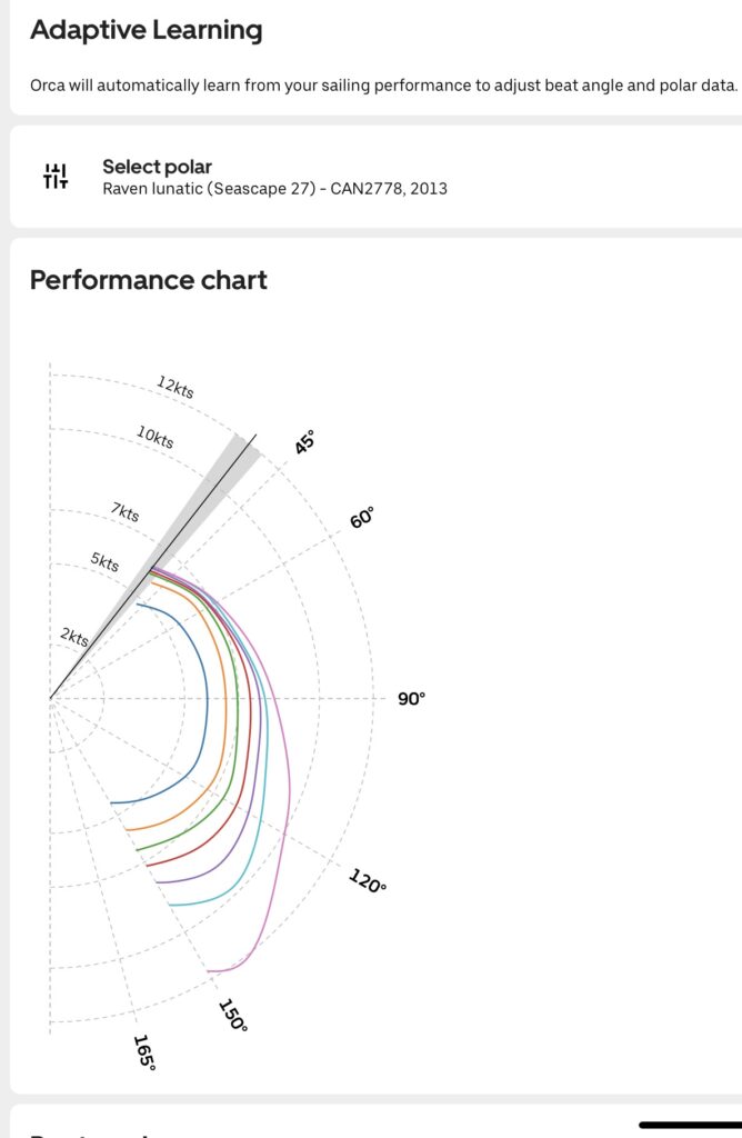
On sailboats you can use “Polar Charts” to map out the “potential” performance of the boat at different wind angles and wind speeds. Garmin, B&G and Raymarine can use polar charts – but getting them into the chart plotters is a PITA involving downloading files and formatting them to something the Chart-plotter can understand, putting them on a memory card and then figuring out which menu to import them from. Well on Orca they are more user friendly. You just open a boat performance screen – search for the boat type – and select from a database of “known” boats matching your type.
But using Polar Charts is not the salvation. Few people can sail at their boats to Polar Chart optimal performance – or chose not to. Sailing close-hauled into a strong wind can be a tough experience for skipper, crew and guests – so unless you are a race fanatic – you probably keep a more balanced pace.
But Orca handles that as well. Orca will use the Polar charts, learn from your sailing behaviour and have so far used those data to plot your courses and routes.
Weather Based Routing
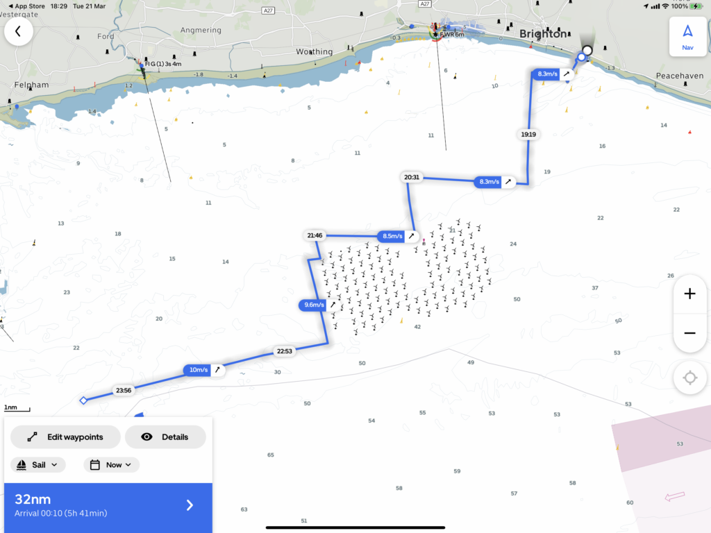
But now with today’s software release – Orca has gotten the full “Weather compensated” routing based on your Polar Charts, Previous learned behaviour and now Wind, Waves and Current.
Planning a route into the wind? Orca will calculate tacks based on all the known parameters. As far as I can tell – it uses actual “timed” weather forecasts – so if you plan a 50-mile trip – it uses “departure time” weather for your start time and then monitor how the weather is supposed to change during your sailing time – and modifies the plan to fit. But we all know that weather forecasts are never static, so time will tell how Orca will behave with weather changes while you are on the route.
If you start your route from inside a harbour – Orca will even show a little “engine” symbol, in the route, until you are out of harbour and can set sails.
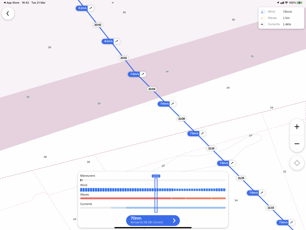
You can inspect the route with a nice graph showing you the Wind, waves and currents underway – and how many manoeuvres you are likely to make. Nice little feature as a pleasure cruise might not be a pleasure if there are too many manoeuvres to do. Tacking down a tiny channel in 15 m/s winds are not my idea of fun with guests on board.
Ohh – and did I mention – you can plan or check a route with weather planning up to 5 days ahead – so if you plan a weekend trip – you can start planning on Monday for Friday departure – and check return weather for Sunday on Wednesday. But then we all know how precise weather forecasts are so always check as close to departure as possible. But we can’t ask Orca for “which day is best for crossing the channel?” (Yet…)
Well right now this has been an “On Land” pre-view test only. But as we seem to maybe get access to a test sailboat very soon – I think the first thing that will happen is we will put an Orca Core on it and hopefully the newly announced Orca Display 2, taking out the “old” Garmin plotter.
Wrap up
All I can say about Orca is that I am impressed. I have not been a big fan of Tablets for main navigation before – but with Orca’s new display that – at least according to published specifications – can compete with the best of the chart-plotters out there – we might finally in a place where the hardware might be able to stand up to the pressure of sun, wind and salt.
Note: Here is further information our opinion on Android Based Chart-plotters. We believe that any marine device, delivered with Android as the base OS (operating system), should have a published guaranteed years of major OS updates and, separately stated, years of security updates.
Don’t get me wrong – Orca is a newcomer – running a marathon. And newcomers makes mistakes. Their software is not bug free and some bugs have stuck around for a while. But if Orca can continue to the pace and have someone to clean up the mess in the rear view mirror – there potentially will NOT be marine products from Garmin, Raymarine or Navico in 6-8 years. On the flip-side it might get the old dusty companies a fresh winds and some more dedication to development. But I doubt it at least for Raymarine & Navico as their owners are both very heavy dance partners with high profit requirements.
If I was Garmin, B&G/Navico/Simrad or Raymarine – I would be worried. If Orca continues at the current pace – Orca will be the company that might buy one of the previously mentioned for their Radar, Sonar and VHF products and become the major player in the marine marketplace. If Orca joined with NKE for low power sailing and racing products B&G would be dead in the water very fast. The combo of great hardware (NKE) AND great user-interface (Orca) would be hard to beat.
Well done Orca!
Well, there are other apps around with a far better overview and information on the chart like e.g. tidal streams (savvy navvy). It’s a beginning for Orca, but still a long way to go. Until then, we still need to use different apps to get tidal stream information, moon situation (spring/neaps) and swell to plan a route. I’ll praise the day, when I can only use a chart plotter app to plan a sailing route.
The only thing worse than the equipment is the customer service …Do not BUY.
Comments are closed.